Thursday, April 28, 2016

Kotor, Montenegro:a little gem no one knows about…yet…

Our two stops in Greece, Crete and Corfu, were not very exciting. In Crete, we just tendered in, walked around a bit, and took an exciting tender ride back to the ship.
 
In Corfu, the weather was a lot nicer so we did about the same thing, but Corfu is "cuter" than Crete. We had a wonderful lunch overlooking the Cricket field (yes, in Corfu, the Greeks are Cricket-crazy rather than football (soccer)-crazy. We also managed to make a minor assist to the Greek economy (ask Bonnie about her new ring...). Then it was back to the ship for our next real port of call, Kotor, Montenegro.
++++++++++++++++++++++++++++++++++++++++++++++
We just finished a delightful day wandering around Kotor. Kotor is, ostensibly, on the Montenegrin coast, but one has to navigate over a kilometer of narrow twisting channels to get from the Adriatic Sea to the Bay of Kotor.

The wall relief map in the Maritime Museum gives a better idea of how we had to "thread the needle" to get in to the dock at Kotor.
 
However, once you get there, it is definitely worth it! We had been to Dubrovnik several times and we will be there again tomorrow for a day. We had also been told by other “seasoned” travelers that Kotor was a “smaller version of Dubrovnik.”
 
The lessen we learned today is that you cannot believe everything you hear – especially if it comes from a few people who consider themselves “real travelers” rather than “just tourists” simply because they took a real flyer and ate lunch in the town…and even had some of the local beer…
 
Kotor is indeed smaller than Dubrovnik. It has about 35,000 total inhabitants – 900 of whom live in the old city – while Dubrovnik has about 43,000 total, of whom almost 28,000 live in the old city. Quite a contrast… But then all of Montenegro only has about 650,000 population compared to Croatia’s 4,250,000.
 
Okay, enough of the statistics. Kotor is a jewel nestled at the base of some of the most magnificent mountains we have ever seen. Since our ship is much smaller than most other cruise ships plying these waters, we were able to dock right in the heart of the city adjacent to the old city walls. A short few hundred feet from the gangway and we were back in the 12th Century again.
From the ship to the central square is only about 500'.

Here are several montages of street scenes. No matter where you look, it just gets better...


Although there was a gigantic earthquake in 1979, Kotor has managed to rebuild without losing its charm and with a monumental restoration program for the old buildings. It was also designated a UNESCO World Heritage site and that certainly helps.
 
We took a short (about two-hour) walking tour of the old city and then got turned loose to browse on our own. The tour began at about 9:00 Am – lucky for us. By noon crowds of bused tourists from eastern Europe and Asia descended on the old city for the afternoon and we made a bee-line back to the ship.
 
The walking tour was only to point out several of the most important historical highlights and to give us a flavor of the city. Our guide, the delightful Slandge (“That’s hard to pronounce, so you can just call me ‘Sweetie’…”) was very knowledgeable and like most eastern Europeans, she spoke better English than one finds in many parts of South Florida…
Sweetie telling us about the city she loves.
 
Almost all of the former Yugoslavian Republics (Slovenia, Croatia, Bosnia and Herzegovina, Montenegro, and Macedonia plus two the autonomous provinces of Kosovo and Vojvodina within Serbia) require English as a second language from the first grade onward. In addition, they also require an “elective” language from the fourth grade onward. Sweetie’s was French. She is a graduate of Kotor’s own College of Tourism and Hospitality. Tourism is the main money-maker for Montenegro; however, they are also blessed with a good agricultural infrastructure and several mineral resources.
 
After our tour, we wandered back to several shops that caught Bonnie’s eye during the tour and got a couple of shirts, some wine (to drink on the ship), and the obligatory refrigerator magnet. The magnet is probably one of the most interesting items we have picked up on the entire cruise. It is a typical 2” X 3” piece, but it is hand-made inlaid glass by a local artist. Although they churn these out by the gross, they are well-made and since they are hand-made, each is just a bit different. All this for only €2.50 (about $3.00).
 
After our contributions to the local economy, we happened upon two of our fellow cruisers at a restaurant we had been considering, so we joined them for a fabulous lunch: I had grilled octopus with garlic spinach and potatoes; Bonnie had grilled squid stuffed with local prosciutto-style ham and local farmer cheese (and the spinach and potatoes). Local wine (her) and beer (me) topped it all off. The tariff for this repast was a mere €31 (about $35). In Dubrovnik (or anywhere else that depends on tourism) it would have been almost half again as much…
 
I remember thinking, when we were in Myanmar visiting Bagan, that in ten years Bagan would be just another tourist attraction (assuming Myanmar gets their political act together). Political issues aside (Montenegro does not really appear to have any), I fear that in much less time, Kotor will be more than a “mini-Dubrovnik” and not the better for it.
 
Here are a few photos of what we saw from the ship on the way in and out.
 
The scenery and history are stupendous, the people are friendly and speak English, the economy is trying to get stable enough to join the EU (they are already on the Euro), the standard of living is at least as high as anyplace else in Europe and higher than several others. They have only to keep up their hard work and hope that their own success does not do them in.
B and me in the central square.
B and me on the dock opposite the ship's berth.
 
Tomorrow we are in Dubrovnik. Since we still have to pack, and since we have been to Dubrovnik several times, we may just take it easy, pack, and make it a sea day. Perhaps we will try for one more great Mediterranean lunch – and another refrigerator magnet. Stay tuned…

A day in the 11th, 12th, and 13th Centuries: Akko (or Acre), Israel

We are docked in Haifa, Israel, the northern large port city.
From Haifa, it is easy to get to the Sea of Galilee, the Golan Heights, Capernaum, and many other well-known sites. However, since we did that the last time we were here, today we opted for something just a bit different. Today we would travel back in time.

However, before we go there, I need to mention something that struck me on the bus trip from Haifa to Acre. As we rolled along the coast road with the Mediterranean Sea on one side and the Judean hills on the other, I noticed a nuclear power plant nestled in among the other industrial sites wee passed. It struck me that here in one of the most recently developed countries in the world (~65 years since independence), one could go from the Crusaders to Nukes in the blink of an eye. The Israelis have so much personally invested in this country it is no wonder they look like 21st Century versus 12th Century in several of the countries we have recently visited. There is a sense of “we are all in this together” that one does not get in other parts of the Middle east. Perhaps that explains so much in itself…

Pretty much anywhere you travel in Israel it is easy to go back in time; however, if you limit yourself to the bigger cities and the popular attractions, then you miss a lot as well. Before I go any further, here is an abbreviated time line of Israel’s history:
Our day began with a short bus ride up the coast about 25 kilometers (~15 miles) to the city of Akko, or Acre as it is more modernly known. Acre was, at the time of the crusades – about the 11th Century – one of the major trading ports on the Mediterranean Sea. It had actually existed for centuries before that, but really came into its own after the Arab traders built the first real city in the 6th Century BC.
As each successive conquering power settled in, they basically leveled the previous city and built a new one on top of the old one. We traveled back to the 11th Century to visit the Crusader Era, about three layers down from the current era.

Before we descended to the ruins, we were take to a viewpoint atop one of the local government buildings so we might be better able to put our upcoming walk into perspective.
From there we walked across the street and back in time about eight Centuries.
On the left our Guide, Eleanor, led us to the dark doorway ahead. The center picture shows the entrance to the underground city: the dark rectangle in the middle of the picture under the stairs. On the right, she is showing us what to expect by using a metal model of the ruins and reconstructions.

As we entered the first pathway, we immediately started down stairs and found ourselves in a large room that was part of the Knights Hospitallers (KH) headquarters. The KH were a monastic military order established to treat the sick in the Holy Land. We spent about two hours exploring almost perfectly restored rooms housing the hospital, the dungeon, the dining hall, and all of the auxiliary functions necessary to sustain a small city.
Yes, that photo on the upper left is what you think it is - a communal Roman toilet... The highlight of this part of the tour was a short walk through a tunnel that might have been hidden once and used as a possible escape route (lower left).

We then visited a recreation of the original Turkish bath. That was sort of interesting, but the Disneyesque opening film was too long and I, at first, thought the entire structure was a re-creation. It turned out that the rooms we passed through were in fact a reconstruction of the original 12th Century Turkish bath.

As we would our way along the outer walls, we made a quick stop at a mosque being restored for the Sufi branch of Islam. The marble and inlay work were beautiful. We were told that it will take about another five years to complete.
We left the underground world of the Crusaders long enough to pop out to the surface to have a view of the harbor and the old city wall. Then it was back underground to follow a tunnel constructed to connect the harbor with the far side of the old city.
Finally, above ground at last for good, we had a short stroll through the “modern” market. The air was alive with the aroma of spices, nuts, sweets, and more than a few unwashed bodies.

Back on the bus again fro the short hop back to Haifa and the obligatory five-minute picture stop atop the Baha'i Gardens and Mausoleum overlook. Since we have a bunch of pictures from that viewpoint from our first visit, we opted to stay on the bus.

So about four hours of walking and learning gave us a new and unique perspective on the Crusades and the subsequent civilization that came after them.

Our next two stops are in Crete and Corfu, Greece. Having been to both, we may opt to make those sea days. Stay tuned…

Masada and the Dead Sea: Israel is a startling contrast to Egypt

We started a long day with a bus ride from our port call at Ashdod on the Mediterranean Sea heading east toward the Dead Sea via Jerusalem.
I am showing Petra since it will figure in as part of the importance of Masada - being on the direct trade route to Jerusalem.
The gold dome is the Dome of the Rock (Islam). Near the exact center of the picture is a dark gray smaller dome that is the Jewish synagogue. Just off to the right of the photo would be the Church of the Holy Sepulcher. All three major religious faiths represented in a triangle in the holiest place in the world within a kilometer of each other.

We made a short overlook stop on Mount Scopus to get a view, and a review, of some of the ancient and modern sites in this wondrous city.

I want to take a moment here to mention that Israel is no more “dangerous” than any other large modern country in the west – America, Europe, Canada, etc. If a bomb or a nutcase can wreak havoc in almost any major American city as has been demonstrated much too amply in the past few years, then the bombs and nutcases in Israel, or anywhere else for that matter, are not that different. In fact, I believe that Israel is one of the safest countries in which to travel. The infrastructure is vastly superior to any other we had thus far seen in the middle east or in southeast Asia. Their internal security is consistently ranked as one of the best, if not the best, in the world. The citizens are more aware of their unique position on the worlds stage than most other countries in the region and, thus, make you feel welcome and safe immediately. Okay, enough of the polemics, I just had to get that off my chest.

We last visited Jerusalem about five years ago and sent a glorious day walking from one “must see” site to another. This time we only had a photo stop, but our guide, Achiya (ach-ee-ya) took the time to give us a quick review of the history and provenance of the major attractions: the Dome of the Rock; the Church of the Holy Sepulcher; the main Synagogue; the Mount of Olives; the Western Wall; and a few others. It was a half-hour well-spent.

Back on the bus and another hour and a half to our first stop – a potty break at Qumran, the site of the discovery of the Dead Sea Scrolls. The restaurant/gift shop/Dead Sea cosmetic palace/toilet facility was doing a thriving business from both souvenir hinters and those trying to buy back youth and vigor by way of Dead Sea mud, salts, and somewhat dubious (to my mind) beautifying skin care products – all at rather “interesting” prices… We did get to see several of the caves as we made our way toward Masada, but the bus didn’t stop so pictures were not possible.

Masada: a mountain stronghold that was originally King Herod’s winter palace. I never knew that Masada was one of the major points in the Roman trade routes from the east. It lies in a direct line between Petra and Jerusalem along the west bank of the Dead Sea. After Herod died in 4 AD, the palace became a retreat for a band of ultra-religious Jews from the Jerusalem area in about 65-66 AD at the time of the Great Revolt against the Romans. These rebels, we know them as the Zealots, were ostracized by their own people for their ultra-conservative views and actions (they apparently had a nasty habit of killing those in strong opposition to their beliefs). The Romans needed to take back the stronghold and laid siege in about 70 AD. What remains of the Masada fortress tells an amazing story of both Roman and Jewish history.
We never thought that some of the best-preserved and most interesting Roman ruins and artifacts we would ever see would be in Israel!

Rather than go through the entire story and the well-laid pathway that the Israeli government has provided for visitors, I will let some of our pictures do the talking.
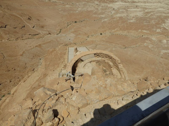
 The arrow shows the bottom cable car station from the top of the mesa.
This is a telephoto shot of one of the eight the Roman Camps (the square thing to the left of the cable car station in the photo above) used to lay siege to Masada in about 70 AD.
A view from the cable car as we came into the top station.
Once up top, we were shown a metal model of the entire site and given a preview of both the history of the site and of what we would be seeing during our walk.
This photo shows a black line running around the perimeter of this room. That line represents the ruins as originally found by the archeologists. Everything above the line is a reconstruction. Everything below the line is original and restored.
Our guide is showing us what we will be seeing when we go to the overlook railing. Every major section of the site had one or more of these metal models to show the detail of that place.
 A panorama from the very top of Masada.
The arrow shows where the panorama above was taken. and where we were stationed to look over the edge.
The view from the top looking down over the guest apartments in Herod's main palace in the complex.
A model of the Roman baths that were constructed on the mountain top. Roman baths in the middle of the desert!!!
The first room was the cold room. A quick dip in cold water to get the blood circulating.
The second room was a plain room that was at "room temperature" to get used to the stifling heat and humidity coming up in the hot room.
The hot room had a raised floor under which hot air was circulated. In addition the hot air was piped along the walls in terra cotta pipes covered with stucco. The bright spots on the far wall are meant to simulate the fires from the outside furnace used to create the hot air (see next photo).
A view from the outside of the hot room showing the furnace used to create the hot air. Keep in mind that this was a wood-fired furnace. Wood in the middle of the desert - had to be hauled in on camels over the sand dunes from Jerusalem.
The siege ramp built on the west side of the mountain. This is all that is left after several millennia, but you can imagine that this ramp was built by slave labor from sand, rocks, debris hauled in from far away.
As we waited fro the cable car to return to earth, I took this shot of a lady and here child near the bottom of the pathway. They had walked down from the top. That speck in the red circle is them.
Here is a zoom blow-up of that speck in the prior photo. 
Here is another similar shot. The man and his son are even farther away than the prior couple.
See, it really is two people.
This is the cable car. It may look small, but it can hold up to 80 people at a time.
 
We then took the cable car back down to our waiting bus for a short hop to the Lot Resort on the edge of the Dead Sea. The Lot is one of about a dozen new hotel-resort complexes that have sprung up along the southern edge of the Israeli side of the Dead Sea. There are several hundred, possibly over 1000 rooms, along with the requisite restaurants, spas, beaches, pools, and playgrounds that now serve both Israeli and foreign nationals as a prime vacation spot. Maybe there is something in that Dead Sea mud after all…

The Lot had spectacularly clean rest rooms – always a plus for North American travelers, and a HUGE buffet for our luncheon. After much munching and a couple adult beverages, we retired to the changing rooms and got ready to do the Dead Sea Float.The Dead sea Float is where you enter the water and lie on your back so you can read a book, take a selfie, or otherwise act touristy. I confess to trying it and then flailing around like an overgrown puppy as I tried desperately to get my legs down so I could get a footing again. Finally, Bonnie had to hold my arm so I could pivot and get my center of gravity under me rather than next to me… That may sound like much ado over little, but you do not want to get any of that lovely, warm, clear, water in your mouth, eyes, nose, open cuts, lacerations or any abrasion. Since the mineral and salt content are around 35%, it burns! I did get a few drops of water in my mouth from all that flailing around and I swear that I can still taste it.
Sadly, we had only about an hour to enjoy the water, so we did our floaty thing, showered on the beach, took to the real swimming pool to try to get the last vestiges of Dead Sea water off, then re-dressed and bused back to the ship. Whew, what a day!

Tomorrow we are docked in Haifa and will be visiting the Crusader city of Acre. That should be yet another view of this fascinating country. Stay tuned…

Saturday, April 23, 2016

Transiting the Suez Canal

We spent a rather uninteresting day transiting the Suez Canal.
The Suez Canal, unlike the engineered wonder that is the Panama Canal, is basically a ditch connecting the Red Sea with the Mediterranean Sea. There are no locks, no grand engineering, no jungle, villages, or other points of interest lining the route. There is sand and occasional guard towers. There is ongoing dredging and maintenance activities. There is one place where several monuments and commemorative pieces have been erected; however, these pass quickly and are forgotten almost as quickly.

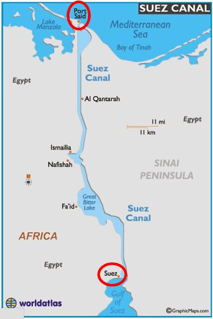
The Canal has been upgraded recently. They added about 72 kilometers of parallel canal and canal connections so that traffic can now flow two ways. Up to this point, traffic had to flow one way from either Port Said in the north or Suez in the south, then wait in Great Bitter Lake for the opposite segment of canal to clear, then continue either north or south.

All traffic had to convoy, so there was, apparently, a lot of jockeying for positions in a convoy. They still convoy, but all northbound traffic including the Silver Whisper, begins a convoy at Suez around 4:00 AM and starts to move northerly. All southbound traffic in a convoy does the same at Port Said. Both convoys can move at all times and there is no more need for one or the other to wait in the lake for traffic to clear. We made the passage in about 12 hours, compared to the old average of 18-20 hours.

The new canal works were built in about a year at a cost of about US$8 billion. There is a great deal of speculation regarding whether or not they will earn back the cost via passage revenues in a reasonable time frame. I have no information on how it was financed, but I suspect that the World Bank had a hand in it.

If you are interested in learning more about the canal – old and new – here is a link to follow: http://www.suezcanal.gov.eg/

I did manage to get a few pictures.
 Sand and dunes for about 10 hours.
 We led the convoy.
 From one side to the other - nothing much more than more sand...
 Every now and then a monument or commemorative structure.

A memorial to the workers.
The largest monument at about midway between Suez and Port Said.
Check out the Panama Canal pix and compare them to what we saw all day long in Suez. After the initial look, it was a good day to just relax, read, and play bridge.

Our next port is Ashdod in Israel. We will be taking a day trip to Masada and the Dead Sea. Stay tuned…